“Climate change is already having an impact on the millions of people who live near China’s glaciers. As temperatures climb, glacial outbursts, flooding, and seasonal water shortages will only become more severe. We have a responsibility to transition away from climate-change causing fossil fuels as quickly as possible and to invest in adaptation strategies that will help protect this fragile region from the most severe impacts.”
As glaciers melt, lakes often form in glacier termini. A glacial lake outburst occurs when a dam made of ice or terminal moraine holding back a glacial lake fails, causing flooding and the release of rocks and other debris.
Since 1961, average annual temperatures in high mountain areas of the Yarkant River Basin, where the glacier outburst occurred, have increased by 3 to 3.5 °C. [3] At lower elevations in the the Yarkant River Basin, annual average temperatures have increased by 2 to 2.5 °C.
Over the past two decades, glacial melt in the Yarkant River Basin has accelerated. A comparison of data from 1961 to 1990 and 1991 to 2006 shows that summertime glacial melt runoff in the Yarkant River increased by 30.5% between the two periods. Glacial mass loss contributed 95.1% of the total increase in runoff. [4]
Total glacial ice volume in the Yarkant River Basin decreased from 730.46 km³ 1968 to 624.01 km³ in 2010, a decline of 14.6%. [5]
On July 20 2018, the Tarim River Basin Management Bureau issued an early warning about a glacial lake outburst in the upper reaches of the Yarkant River. [6] Greenpeace analysis of satellite imagery showed rapid expansion of the glacial lake in late July and early August.
Between 15 and 20 hours after the outburst occurred, the Kuluk Hydrometric Station recorded a peak discharge of 1570 m³/second.
There are 3,247 glaciers in the Yarkant River Basin. [7] China is home to more than 46,000 glaciers, which form part of the Third Pole — the third largest concentration of snow and ice in the world. Temperatures in the Third Pole are increasing at a rate that is twice the global average. [8]
From Dr. Shen Yongping, research fellow, Northwest Institute of Eco-Environment and Resources, Chinese Academy of Science:
“Since 1987, the climate in arid regions of Northwest China has shifted from warm-dry to warm-humid, which means that average annual temperatures and precipitation have increased dramatically in recent decades. Climate change has caused the acceleration of glacier mass loss and an increase in glacial runoff in arid regions of Northwest China and has led to more frequent glacial floods and debris flows. As global climate change accelerates, we should further strengthen impact assessments of climate change in cryospheric regions and the implementation of adaptive countermeasures. Science and technology should play a leading role in disaster reduction.”
Notes to Editors:
[1] http://news.cctv.com/2018/08/12/ARTIq6IiDdxNmQG1PhjBWTmQ180812.shtml
[2] http://www.xinhuanet.com/local/2018-08/10/c_1123253623.htm
[3] Temperature data from Taxkorgan Meteorological Station and Shache Meteorological Station.
[4] Gao, Zhang, Ye, Qiao, 2010, Glacier runoff change in the upper stream of Yarkant River and its impact on river runoff during 1961-2006, Journal of glaciology and geocryology, 32(3):445-453
[5] Feng, Liu, Xu et al. 2015, Glacier change of the Yarkant River basin from 1968 to 2009 derived from the First and Second Glacier Inventories of China, Journal of Glaciology and Geocryology, 37(1): 1-13
[6] http://www.tahe.gov.cn/item/30141.aspx
[7] Feng, Liu, Xu et al., 2015.
[8] Chen, Xu, Yao, et al., 2015, Assessment of past, present and future environmental changes on the Tibetan Plateau, Chinese Science Bulletin, 60(32): 3025-3035
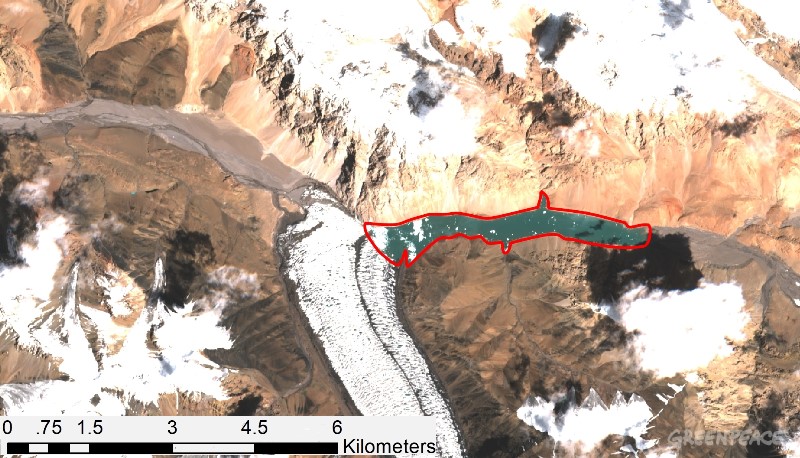
(above) This August 6, 2018 Sentinel 2 satellite image shows the formation of a glacial lake (outlined in red) in the Yarkant River Basin.
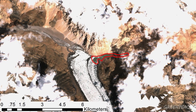
(above) This August 11, 2018 Sentinel 2 satellite image shows the reduced size of a glacial lake (outlined in red) in the Yarkant River Basin following a glacial lake outburst that occurred in the early morning of August 10, 2018. Floodwaters are visible to the left of the lake.
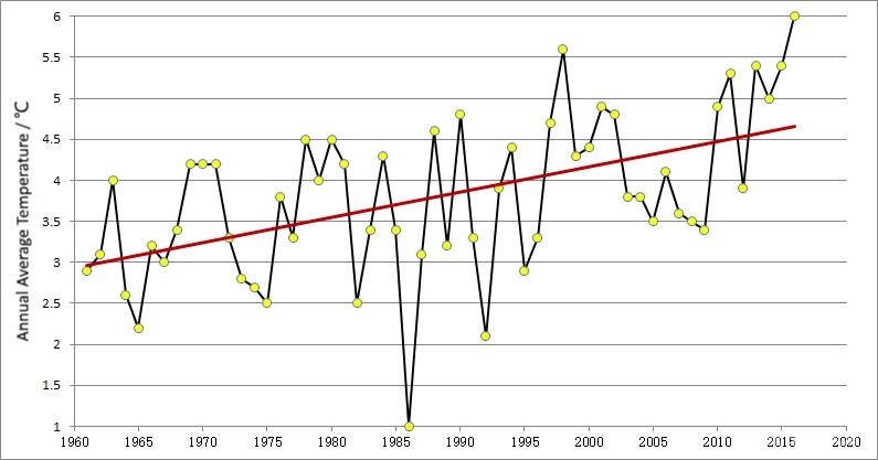
Annual average temperatures at Taxkorgan Meteorological Station, Yarkant River Basin (high mountain area), 1961-2016.
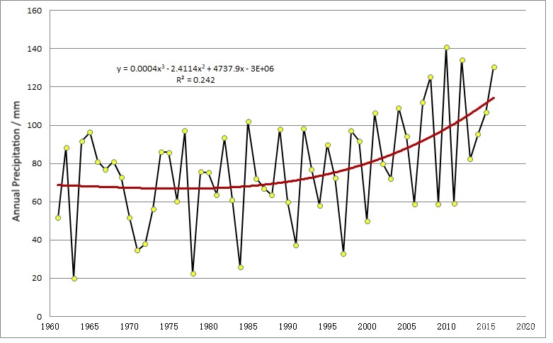
Annual precipitation at Taxkorgan Meteorological Station, Yarkant River Basin (high mountain area), 1961-2016.
Media contacts:
Erin Newport, International Communications Officer
Greenpeace East Asia, Beijing | +86 18301149704 | [email protected]
Greenpeace International Press Desk, [email protected], phone: +31 (0) 20 718 2470 (available 24 hours)