Greenpeace demands urgent action as costs to threaten millions of Filipinos

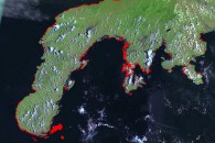
Satellite map of the province of Sulu in the Philippines. Red markings indicate areas that are vulnerable to a one meter rise in sea level.
Sulu ranks first as the province most vulnerable to an increase in sea level in terms of land area that is at threat. A one meter rise in sea level is projected to inundate 7,972.83 hectares of land. At least 90% of the land area of the Municipality of Pata and 34% of the Municipality of Marunggas, both in the province of Sulu, are at threat, potentially displacing communities, damaging infrastructure, and affecting livelihood.
Sulu is in the southernmost part of the Philippines about 950 kilometers from Manila. It has a population of at least 619,668 people which includes the Badjaos or “sea gypsies” of the Sulu seas . It is famous for its Pearl Farm in Marunggas Island as well its white sand beaches and coral reefs.

Satellite map of the province of Palawan in the Philippines. Red markings indicate areas that are vulnerable to a one meter rise in sea level.
Palawan ranks second as the province most vulnerable to an increase in sea level in terms of land area that is at threat. A one meter rise in sea level is projected to inundate 6,428.16 hectares of land.
Palawan is considered as the Philippine’s last frontier. It is approximately 586 kilometers southwest of Manila. It has a population of at least 755,412 people from 81 cultural groups. It is famous for its World Heritage Sites–the Puerto Princesa Subterranean River National Park and the Tubbataha Reef Marine Park.

Satellite map of the province of Camarines Sur. Red markings indicate areas that are vulnerable to a onemeter rise in sea level.
Camarines Sur ranks tenth as the province most vulnerable to an increase in sea level in terms of land area that is at threat. A one meter rise in sea level is projected to inundate 2,268 hectares of land.
The province is approximately 450 kilometers southeast of Manila. It has a population of at least 1,551,549 people. Ironically, Camarines Sur is not only vulnerable to sea level rise it is also considered as a province that is highly at risk to typhoons and variability in precipitation.

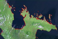
Satellite map of the Zamboanga Peninsula in the Philippines. Red markings indicate areas that arevulnerable to a one meter rise in sea level.
Zamboanga del Sur, Zamboanga Sibugay and Zamboanga del Norte rank third, fifth, and nineteenth as the provinces most vulnerable to an increase in sea level in terms of land area that is at threat. A one meter rise in sea level is projected to inundate 3,781.89 hectares in Zamboanga del Sur, 3,274.02 hectares in Zamboanga Sibugay and 1,057.05 hectares in Zamboanga del Norte.
Zamboanga del Sur, Zamboanga Sibugay and Zamboanga del Norte comprise the Zamboanga Peninsula or Region 9 which has 5 major cities. It is situated in Mindanao Island, about 800 kilometers south of Manila.
The map indicates that Region 9 is the second province most vulnerable to sea level rise.

Map of the Philippines indicating tragedies from 1991 to 2006 triggered by extreme weather events such as typhoons and increase in rain fall.
This list of tragedies include the Legazpi Mudslide and the Guinsaugon, Leyte Landslide which the Center for Research on the Epidemiology of Disasters declared as 2nd and 3rd of the World’s Deadliest Disasters of 2006, respectively. A total of 2,511 people were killed and almost 800,000 families were affected by these tragedies.
The maps accompanied the briefing paper “The Philippines: A
Climate Hotspot” which gives an overview of how extreme weather
events and sea level rise threaten the country’s people, economy,
species, and ecosystems. Notably, the new Greenpeace report shows
how: 1) only 1 of the 16 regions of the Philippines is not
vulnerable to a one meter rise in sea level, 2) the regions and
provinces most susceptible to sea level rise, extreme weather
events, and landslides are also among those with the highest
poverty incidence, and 3) the cost of the impacts of extreme
weather events brought about by typhoons and increased rainfall,
already in the hundred millions, is steadily rising.
The paper was released ahead of the conclusion of the
Intergovernmental Panel on Climate Change (IPCC) meeting in
Brussels this week which updates its assessment of the global
impacts of climate change this Friday.
“As experts predict that climate change impacts will continue to
worsen in the coming decades, the question is how much will the
country be affected. Unfortunately what we’ve discovered is that
the stakes are much higher than what we’ve originally imagined. The
entire Philippines is a climate hotspot, vulnerable to the worst
manifestations of climate change. And unless this disaster is
averted, the costs in human lives and economic losses will continue
to rise to catastrophic proportions,” said Greenpeace Southeast
Asia Climate and Energy Campaigner Abigail Jabines.
The maps also show how climate change can irrevocably alter the
country’s coastline. An indicative one-meter rise in sea level for
example is projected to affect 64 out of 81 provinces, covering at
least 703 out of 1,610 municipalities and inundating almost 700
million square meters of land. A one meter rise in global sea level
can occur sooner with the melting of the Greenland and West
Antarctica ice sheets if global carbon dioxide emissions are not
immediately curbed. In the worst case scenario involving the
complete melting of the said ice sheets, global sea level is
projected to rise from between seven to twelve meters.
“As a developing country with very little access to vital
resources, the Philippines has a low ability to adapt and a lower
ability to cope with disasters brought about by climate change
impacts. Aside from recurring typhoons and drought, sea level rise
is a major threat to marine ecosystems and to coastal human
populations and their livelihoods. But another grim reality is that
climate change not only exacerbates the Philippines’ socio-economic
and environmental problems, it also threatens the country’s rich
cultural heritage, as well as some of the rarest and most diverse
fragile ecosystems in the world. And still grimmer is the fact that
climate change will amplify the socio-economic burdens already
shouldered by Filipino families, such as hunger and water
scarcity,” said Jabines.
Greenpeace says, it’s not too late. There is still time to avert
the worst impacts of climate change–if we act decisively now. As a
start, immediate measures must take into account how local
governments can adapt to the worsening forecasts through effective
coping strategies and disaster preparedness. However, the stronger
and more necessary solution is the global reduction of greenhouse
gas emissions by 50% by 2050. To help reach this goal, the
Philippines must start reducing its dependence on fossil fuels,
particularly coal, for its energy source. The country must embrace
renewable energy and promote energy efficiency to cut carbon
dioxide emissions by as much as 30% by 2050. And to achieve this,
it is imperative that the government implement policy mechanisms,
such as a strong Renewable Energy Bill, to initiate the change.
Being among the most at risk, our country must make greater
leaps toward lasting solutions. Thus, while our government must
anticipate and squarely face the worst of the impacts, it must
above all choose an energy development path built on clean and
renewable sources of energy and energy efficiency to pave the way
for a truly secure and sustainable future,” added Jabines.